 |
 |
|
|
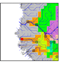
| Station Name (GRDC ID): | Oualia (1112320) | Basin Name: | Gambia |
|---|---|---|---|
| River Name: | Bakoye | Next Downstream Station: | None |
| GRDC Country Code: | MI | Distance to Next Downstream Station: | N.A. |
| Start Year [Month]: | 1951 [5] | Upstream Station(s): | Gouloumbou (1813200) |
| End Year [Month]: | 1990 [12] | ||
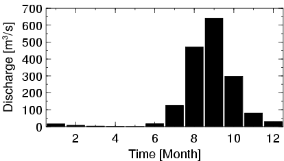
| Mean Discharge: | 141 m3/s | ||
| Minimum Discharge: | 0 m3/s | ||
| Maximum Discharge: | 1382 m3/s | Length of Upstream Mainstem: | 745 km |
| Mean Interstation Discharge: | -8 m3/s | Distance to Basin Outlet: | 54 km |
| GRDC Catchment Area: | 84400 km2 | STN Catchment Area: | 72190 km2 |
| GRDC Interstation Area: | 42400 km2 | STN Interstation Area: | 27017 km2 |
| GRDC Station Runoff: | 53 mm/yr | STN Station Runoff: | 62 mm/yr |
| GRDC Interstation Runoff: | -6 mm/yr | STN Interstation Runoff: | -10 mm/yr |
| Station Field Descriptions | Basin Field Descriptions | ||
| Download | |
|---|---|
| Site Descriptor Information | Station Time Series Data |
| Hydrograph | Station Data | ||||||||||||||||||||||||||||||||||||||||||||||||||||||||
|---|---|---|---|---|---|---|---|---|---|---|---|---|---|---|---|---|---|---|---|---|---|---|---|---|---|---|---|---|---|---|---|---|---|---|---|---|---|---|---|---|---|---|---|---|---|---|---|---|---|---|---|---|---|---|---|---|---|
|
| ||||||||||||||||||||||||||||||||||||||||||||||||||||||||
