 |
 |
|
|
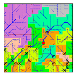
| Station Name (GRDC ID): | Mopti (1134500) | Basin Name: | Niger |
|---|---|---|---|
| River Name: | Niger | Next Downstream Station: | Dire (1134700) |
| GRDC Country Code: | MI | Distance to Next Downstream Station: | 188 km |
| Start Year [Month]: | 1922 [6] | Upstream Station(s): | Kirango aval (1134250) Douna (1134300) |
| End Year [Month]: | 1990 [12] | ||
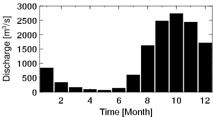
| Mean Discharge: | 1101 m3/s | ||
| Minimum Discharge: | 5 m3/s | ||
| Maximum Discharge: | 3216 m3/s | Length of Upstream Mainstem: | 1004 km |
| Mean Interstation Discharge: | -702 m3/s | Distance to Basin Outlet: | 2453 km |
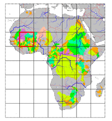
| GRDC Catchment Area: | 281600 km2 | STN Catchment Area: | 308186 km2 |
| GRDC Interstation Area: | 43000 km2 | STN Interstation Area: | 68688 km2 |
| GRDC Station Runoff: | 123 mm/yr | STN Station Runoff: | 113 mm/yr |
| GRDC Interstation Runoff: | -515 mm/yr | STN Interstation Runoff: | -322 mm/yr |
| Station Field Descriptions | Basin Field Descriptions | ||
| Download | |
|---|---|
| Site Descriptor Information | Station Time Series Data |
| Hydrograph | Station Data | ||||||||||||||||||||||||||||||||||||||||||||||||||||||||
|---|---|---|---|---|---|---|---|---|---|---|---|---|---|---|---|---|---|---|---|---|---|---|---|---|---|---|---|---|---|---|---|---|---|---|---|---|---|---|---|---|---|---|---|---|---|---|---|---|---|---|---|---|---|---|---|---|---|
|
| ||||||||||||||||||||||||||||||||||||||||||||||||||||||||
