 |
 |
|
|
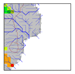
| Station Name (GRDC ID): | Mandini (1160880) | Basin Name: | GHAASBasin444 |
|---|---|---|---|
| River Name: | Tugela | Next Downstream Station: | None |
| GRDC Country Code: | ZA | Distance to Next Downstream Station: | N.A. |
| Start Year [Month]: | 1964 [10] | Upstream Station(s): | None |
| End Year [Month]: | 1986 [9] | ||
| Mean Discharge: | 100 m3/s | ||
| Minimum Discharge: | 1 m3/s | ||
| Maximum Discharge: | 1117 m3/s | Length of Upstream Mainstem: | 382 km |
| Mean Interstation Discharge: | 100 m3/s | Distance to Basin Outlet: | 74 km |
| GRDC Catchment Area: | 28920 km2 | STN Catchment Area: | 29901 km2 |
| GRDC Interstation Area: | 28920 km2 | STN Interstation Area: | 29901 km2 |
| GRDC Station Runoff: | 109 mm/yr | STN Station Runoff: | 106 mm/yr |
| GRDC Interstation Runoff: | 109 mm/yr | STN Interstation Runoff: | 106 mm/yr |
| Station Field Descriptions | Basin Field Descriptions | ||
| Download | |
|---|---|
| Site Descriptor Information | Station Time Series Data |
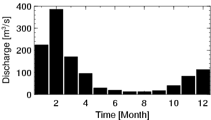
| Hydrograph | Station Data | ||||||||||||||||||||||||||||||||||||||||||||||||||||||||
|---|---|---|---|---|---|---|---|---|---|---|---|---|---|---|---|---|---|---|---|---|---|---|---|---|---|---|---|---|---|---|---|---|---|---|---|---|---|---|---|---|---|---|---|---|---|---|---|---|---|---|---|---|---|---|---|---|---|
|
| ||||||||||||||||||||||||||||||||||||||||||||||||||||||||
