 |
 |
|
|
| Station Name (GRDC ID): | Mbalmayo (1339500) | Basin Name: | Zaire |
|---|---|---|---|
| River Name: | Nyong | Next Downstream Station: | Ngbala (1448050) |
| GRDC Country Code: | CM | Distance to Next Downstream Station: | 356 km |
| Start Year [Month]: | 1951 [1] | Upstream Station(s): | None |
| End Year [Month]: | 1979 [12] | ||
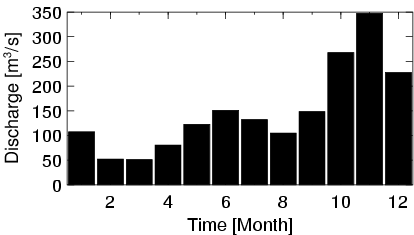
| Mean Discharge: | 149 m3/s | ||
| Minimum Discharge: | 17 m3/s | ||
| Maximum Discharge: | 539 m3/s | Length of Upstream Mainstem: | 190 km |
| Mean Interstation Discharge: | 149 m3/s | Distance to Basin Outlet: | 1753 km |
| GRDC Catchment Area: | 13555 km2 | STN Catchment Area: | 12345 km2 |
| GRDC Interstation Area: | 13555 km2 | STN Interstation Area: | 12345 km2 |
| GRDC Station Runoff: | 348 mm/yr | STN Station Runoff: | 382 mm/yr |
| GRDC Interstation Runoff: | 348 mm/yr | STN Interstation Runoff: | 382 mm/yr |
| Station Field Descriptions | Basin Field Descriptions | ||
| Download | |
|---|---|
| Site Descriptor Information | Station Time Series Data |
| Hydrograph | Station Data | ||||||||||||||||||||||||||||||||||||||||||||||||||||||||
|---|---|---|---|---|---|---|---|---|---|---|---|---|---|---|---|---|---|---|---|---|---|---|---|---|---|---|---|---|---|---|---|---|---|---|---|---|---|---|---|---|---|---|---|---|---|---|---|---|---|---|---|---|---|---|---|---|---|
|
| ||||||||||||||||||||||||||||||||||||||||||||||||||||||||
