 |
 |
|
|
| Station Name (GRDC ID): | Bevoay (1389090) | Basin Name: | Mangoky |
|---|---|---|---|
| River Name: | Mangoky | Next Downstream Station: | None |
| GRDC Country Code: | MG | Distance to Next Downstream Station: | N.A. |
| Start Year [Month]: | 1964 [11] | Upstream Station(s): | None |
| End Year [Month]: | 1983 [10] | ||
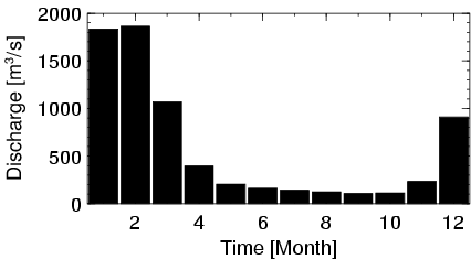
| Mean Discharge: | 597 m3/s | ||
| Minimum Discharge: | 30 m3/s | ||
| Maximum Discharge: | 4980 m3/s | Length of Upstream Mainstem: | 410 km |
| Mean Interstation Discharge: | 597 m3/s | Distance to Basin Outlet: | 128 km |
| GRDC Catchment Area: | 53225 km2 | STN Catchment Area: | 54530 km2 |
| GRDC Interstation Area: | 53225 km2 | STN Interstation Area: | 54530 km2 |
| GRDC Station Runoff: | 353 mm/yr | STN Station Runoff: | 345 mm/yr |
| GRDC Interstation Runoff: | 353 mm/yr | STN Interstation Runoff: | 345 mm/yr |
| Station Field Descriptions | Basin Field Descriptions | ||
| Download | |
|---|---|
| Site Descriptor Information | Station Time Series Data |
| Hydrograph | Station Data | ||||||||||||||||||||||||||||||||||||||||||||||||||||||||
|---|---|---|---|---|---|---|---|---|---|---|---|---|---|---|---|---|---|---|---|---|---|---|---|---|---|---|---|---|---|---|---|---|---|---|---|---|---|---|---|---|---|---|---|---|---|---|---|---|---|---|---|---|---|---|---|---|---|
|
| ||||||||||||||||||||||||||||||||||||||||||||||||||||||||
