 |
 |
|
|
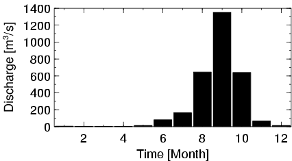
| Station Name (GRDC ID): | Nawuni (1531450) | Basin Name: | Volta |
|---|---|---|---|
| River Name: | White Volta | Next Downstream Station: | Senchi(Halcrow) (1531700) |
| GRDC Country Code: | GH | Distance to Next Downstream Station: | 590 km |
| Start Year [Month]: | 1953 [5] | Upstream Station(s): | Yagaba (1531420) Pwalagu (1531550) |
| End Year [Month]: | 1974 [2] | ||
| Mean Discharge: | 249 m3/s | ||
| Minimum Discharge: | 1 m3/s | ||
| Maximum Discharge: | 1900 m3/s | Length of Upstream Mainstem: | 633 km |
| Mean Interstation Discharge: | 89 m3/s | Distance to Basin Outlet: | 701 km |
| GRDC Catchment Area: | 92950 km2 | STN Catchment Area: | 102902 km2 |
| GRDC Interstation Area: | 19000 km2 | STN Interstation Area: | 24290 km2 |
| GRDC Station Runoff: | 85 mm/yr | STN Station Runoff: | 76 mm/yr |
| GRDC Interstation Runoff: | 148 mm/yr | STN Interstation Runoff: | 116 mm/yr |
| Station Field Descriptions | Basin Field Descriptions | ||
| Download | |
|---|---|
| Site Descriptor Information | Station Time Series Data |
| Hydrograph | Station Data | ||||||||||||||||||||||||||||||||||||||||||||||||||||||||
|---|---|---|---|---|---|---|---|---|---|---|---|---|---|---|---|---|---|---|---|---|---|---|---|---|---|---|---|---|---|---|---|---|---|---|---|---|---|---|---|---|---|---|---|---|---|---|---|---|---|---|---|---|---|---|---|---|---|
|
| ||||||||||||||||||||||||||||||||||||||||||||||||||||||||
