 |
 |
|
|
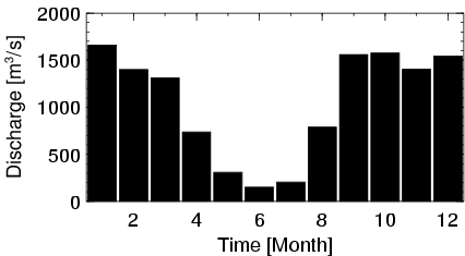
| Station Name (GRDC ID): | Malanville (1734500) | Basin Name: | Niger |
|---|---|---|---|
| River Name: | Niger | Next Downstream Station: | None |
| GRDC Country Code: | BJ | Distance to Next Downstream Station: | N.A. |
| Start Year [Month]: | 1952 [7] | Upstream Station(s): | Niamey (1234150) Diongore amont (1234180) |
| End Year [Month]: | 1992 [12] | ||
| Mean Discharge: | 1053 m3/s | ||
| Minimum Discharge: | 18 m3/s | ||
| Maximum Discharge: | 2726 m3/s | Length of Upstream Mainstem: | 2367 km |
| Mean Interstation Discharge: | 154 m3/s | Distance to Basin Outlet: | 1111 km |
| GRDC Catchment Area: | 1000000 km2 | STN Catchment Area: | 1399238 km2 |
| GRDC Interstation Area: | 284650 km2 | STN Interstation Area: | 590016 km2 |
| GRDC Station Runoff: | 33 mm/yr | STN Station Runoff: | 24 mm/yr |
| GRDC Interstation Runoff: | 17 mm/yr | STN Interstation Runoff: | 8 mm/yr |
| Station Field Descriptions | Basin Field Descriptions | ||
| Download | |
|---|---|
| Site Descriptor Information | Station Time Series Data |
| Hydrograph | Station Data | ||||||||||||||||||||||||||||||||||||||||||||||||||||||||
|---|---|---|---|---|---|---|---|---|---|---|---|---|---|---|---|---|---|---|---|---|---|---|---|---|---|---|---|---|---|---|---|---|---|---|---|---|---|---|---|---|---|---|---|---|---|---|---|---|---|---|---|---|---|---|---|---|---|
|
| ||||||||||||||||||||||||||||||||||||||||||||||||||||||||
