 |
 |
|
|
| Station Name (GRDC ID): | Dapola (1931400) | Basin Name: | Volta |
|---|---|---|---|
| River Name: | Mou Houn (Volta Noire) | Next Downstream Station: | Bamboi (1531100) |
| GRDC Country Code: | HV | Distance to Next Downstream Station: | 434 km |
| Start Year [Month]: | 1951 [3] | Upstream Station(s): | Boromo (1931370) |
| End Year [Month]: | 1991 [2] | ||
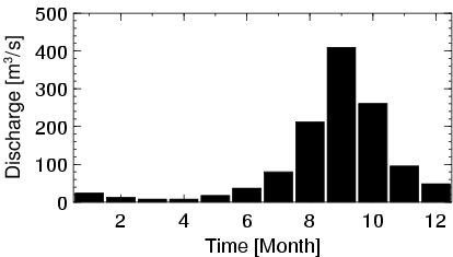
| Mean Discharge: | 101 m3/s | ||
| Minimum Discharge: | 0 m3/s | ||
| Maximum Discharge: | 840 m3/s | Length of Upstream Mainstem: | 410 km |
| Mean Interstation Discharge: | 68 m3/s | Distance to Basin Outlet: | 946 km |
| GRDC Catchment Area: | 66540 km2 | STN Catchment Area: | 75498 km2 |
| GRDC Interstation Area: | 29400 km2 | STN Interstation Area: | 18175 km2 |
| GRDC Station Runoff: | 48 mm/yr | STN Station Runoff: | 42 mm/yr |
| GRDC Interstation Runoff: | 73 mm/yr | STN Interstation Runoff: | 118 mm/yr |
| Station Field Descriptions | Basin Field Descriptions | ||
| Download | |
|---|---|
| Site Descriptor Information | Station Time Series Data |
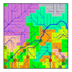
| Hydrograph | Station Data | ||||||||||||||||||||||||||||||||||||||||||||||||||||||||
|---|---|---|---|---|---|---|---|---|---|---|---|---|---|---|---|---|---|---|---|---|---|---|---|---|---|---|---|---|---|---|---|---|---|---|---|---|---|---|---|---|---|---|---|---|---|---|---|---|---|---|---|---|---|---|---|---|---|
|
| ||||||||||||||||||||||||||||||||||||||||||||||||||||||||
