 |
 |
|
|
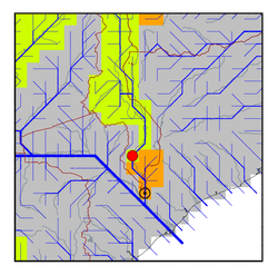
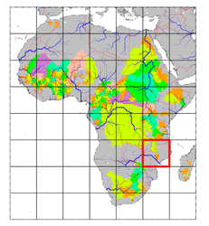
| Station Name (GRDC ID): | Liwonde (1992700) | Basin Name: | Zambezi |
|---|---|---|---|
| River Name: | Shire | Next Downstream Station: | Chiromo (1992900) |
| GRDC Country Code: | MW | Distance to Next Downstream Station: | 188 km |
| Start Year [Month]: | 1965 [1] | Upstream Station(s): | None |
| End Year [Month]: | 1984 [12] | ||
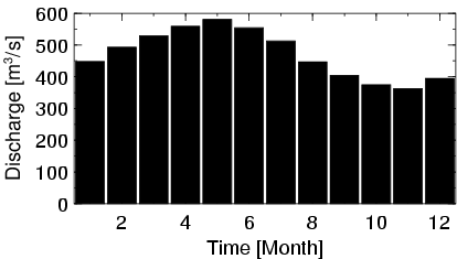
| Mean Discharge: | 472 m3/s | ||
| Minimum Discharge: | 3 m3/s | ||
| Maximum Discharge: | 963 m3/s | Length of Upstream Mainstem: | 889 km |
| Mean Interstation Discharge: | 472 m3/s | Distance to Basin Outlet: | 474 km |
| GRDC Catchment Area: | 130200 km2 | STN Catchment Area: | 123809 km2 |
| GRDC Interstation Area: | 130200 km2 | STN Interstation Area: | 123809 km2 |
| GRDC Station Runoff: | 114 mm/yr | STN Station Runoff: | 120 mm/yr |
| GRDC Interstation Runoff: | 114 mm/yr | STN Interstation Runoff: | 120 mm/yr |
| Station Field Descriptions | Basin Field Descriptions | ||
| Download | |
|---|---|
| Site Descriptor Information | Station Time Series Data |
| Hydrograph | Station Data | ||||||||||||||||||||||||||||||||||||||||||||||||||||||||
|---|---|---|---|---|---|---|---|---|---|---|---|---|---|---|---|---|---|---|---|---|---|---|---|---|---|---|---|---|---|---|---|---|---|---|---|---|---|---|---|---|---|---|---|---|---|---|---|---|---|---|---|---|---|---|---|---|---|
|
| ||||||||||||||||||||||||||||||||||||||||||||||||||||||||
