 |
 |
|
|
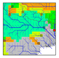
| Station Name (GRDC ID): | Bahadurabad (2651100) | Basin Name: | Ganges |
|---|---|---|---|
| River Name: | Brahmaputra | Next Downstream Station: | None |
| GRDC Country Code: | BW | Distance to Next Downstream Station: | N.A. |
| Start Year [Month]: | 1969 [1] | Upstream Station(s): | Mathanguri (2851250) Pandu (2851300) |
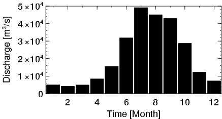
| End Year [Month]: | 1992 [3] | ||
| Mean Discharge: | 21261 m3/s | ||
| Minimum Discharge: | 3314 m3/s | ||
| Maximum Discharge: | 59325 m3/s | Length of Upstream Mainstem: | 2415 km |
| Mean Interstation Discharge: | 1937 m3/s | Distance to Basin Outlet: | 338 km |
| GRDC Catchment Area: | 636130 km2 | STN Catchment Area: | 554542 km2 |
| GRDC Interstation Area: | 198360 km2 | STN Interstation Area: | 116081 km2 |
| GRDC Station Runoff: | 1054 mm/yr | STN Station Runoff: | 1209 mm/yr |
| GRDC Interstation Runoff: | 308 mm/yr | STN Interstation Runoff: | 526 mm/yr |
| Station Field Descriptions | Basin Field Descriptions | ||
| Download | |
|---|---|
| Site Descriptor Information | Station Time Series Data |
| Hydrograph | Station Data | ||||||||||||||||||||||||||||||||||||||||||||||||||||||||
|---|---|---|---|---|---|---|---|---|---|---|---|---|---|---|---|---|---|---|---|---|---|---|---|---|---|---|---|---|---|---|---|---|---|---|---|---|---|---|---|---|---|---|---|---|---|---|---|---|---|---|---|---|---|---|---|---|---|
|
| ||||||||||||||||||||||||||||||||||||||||||||||||||||||||
