 |
 |
|
|
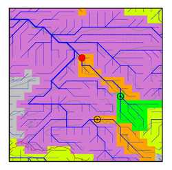
| Station Name (GRDC ID): | Tomsk (2910300) | Basin Name: | Ob |
|---|---|---|---|
| River Name: | Tom | Next Downstream Station: | Salekhard (2912600) |
| GRDC Country Code: | RS | Distance to Next Downstream Station: | 1969 km |
| Start Year [Month]: | 1965 [1] | Upstream Station(s): | Novokuznetsk (2910490) |
| End Year [Month]: | 1990 [12] | ||
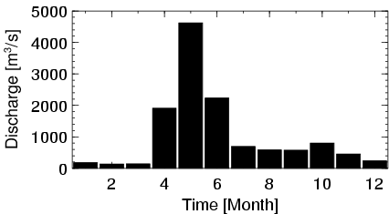
| Mean Discharge: | 1047 m3/s | ||
| Minimum Discharge: | 64 m3/s | ||
| Maximum Discharge: | 7500 m3/s | Length of Upstream Mainstem: | 625 km |
| Mean Interstation Discharge: | 396 m3/s | Distance to Basin Outlet: | 2079 km |
| GRDC Catchment Area: | 57000 km2 | STN Catchment Area: | 57736 km2 |
| GRDC Interstation Area: | 27200 km2 | STN Interstation Area: | 26295 km2 |
| GRDC Station Runoff: | 579 mm/yr | STN Station Runoff: | 572 mm/yr |
| GRDC Interstation Runoff: | 459 mm/yr | STN Interstation Runoff: | 475 mm/yr |
| Station Field Descriptions | Basin Field Descriptions | ||
| Download | |
|---|---|
| Site Descriptor Information | Station Time Series Data |
| Hydrograph | Station Data | ||||||||||||||||||||||||||||||||||||||||||||||||||||||||
|---|---|---|---|---|---|---|---|---|---|---|---|---|---|---|---|---|---|---|---|---|---|---|---|---|---|---|---|---|---|---|---|---|---|---|---|---|---|---|---|---|---|---|---|---|---|---|---|---|---|---|---|---|---|---|---|---|---|
|
| ||||||||||||||||||||||||||||||||||||||||||||||||||||||||
