 |
 |
|
|
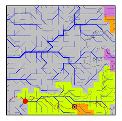
| Station Name (GRDC ID): | Kushum (2919200) | Basin Name: | Ural |
|---|---|---|---|
| River Name: | Ural | Next Downstream Station: | None |
| GRDC Country Code: | KZ | Distance to Next Downstream Station: | N.A. |
| Start Year [Month]: | 1915 [1] | Upstream Station(s): | Aktubinsk (2919500) |
| End Year [Month]: | 1984 [12] | ||
| Mean Discharge: | 297 m3/s | ||
| Minimum Discharge: | 12 m3/s | ||
| Maximum Discharge: | 4800 m3/s | Length of Upstream Mainstem: | 955 km |
| Mean Interstation Discharge: | 282 m3/s | Distance to Basin Outlet: | 521 km |
| GRDC Catchment Area: | 190000 km2 | STN Catchment Area: | 187003 km2 |
| GRDC Interstation Area: | 179000 km2 | STN Interstation Area: | 175205 km2 |
| GRDC Station Runoff: | 49 mm/yr | STN Station Runoff: | 50 mm/yr |
| GRDC Interstation Runoff: | 50 mm/yr | STN Interstation Runoff: | 51 mm/yr |
| Station Field Descriptions | Basin Field Descriptions | ||
| Download | |
|---|---|
| Site Descriptor Information | Station Time Series Data |
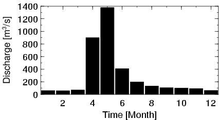
| Hydrograph | Station Data | ||||||||||||||||||||||||||||||||||||||||||||||||||||||||
|---|---|---|---|---|---|---|---|---|---|---|---|---|---|---|---|---|---|---|---|---|---|---|---|---|---|---|---|---|---|---|---|---|---|---|---|---|---|---|---|---|---|---|---|---|---|---|---|---|---|---|---|---|---|---|---|---|---|
|
| ||||||||||||||||||||||||||||||||||||||||||||||||||||||||
