 |
 |
|
|
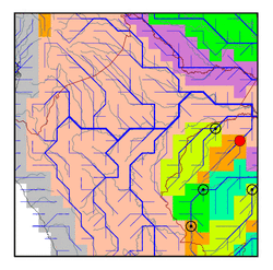
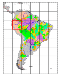
| Station Name (GRDC ID): | Seringal do Itui (3622801) | Basin Name: | Amazon |
|---|---|---|---|
| River Name: | Rio Itui | Next Downstream Station: | Sao Paulo de Olivenca (3623100) |
| GRDC Country Code: | BZ | Distance to Next Downstream Station: | 190 km |
| Start Year [Month]: | 1980 [10] | Upstream Station(s): | None |
| End Year [Month]: | 1992 [7] | ||
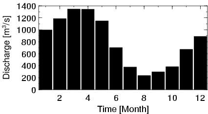
| Mean Discharge: | 798 m3/s | ||
| Minimum Discharge: | 26 m3/s | ||
| Maximum Discharge: | 1602 m3/s | Length of Upstream Mainstem: | 314 km |
| Mean Interstation Discharge: | 798 m3/s | Distance to Basin Outlet: | 2576 km |
| GRDC Catchment Area: | 19103 km2 | STN Catchment Area: | 24599 km2 |
| GRDC Interstation Area: | 19103 km2 | STN Interstation Area: | 24599 km2 |
| GRDC Station Runoff: | 1317 mm/yr | STN Station Runoff: | 1023 mm/yr |
| GRDC Interstation Runoff: | 1317 mm/yr | STN Interstation Runoff: | 1023 mm/yr |
| Station Field Descriptions | Basin Field Descriptions | ||
| Download | |
|---|---|
| Site Descriptor Information | Station Time Series Data |
| Hydrograph | Station Data | ||||||||||||||||||||||||||||||||||||||||||||||||||||||||
|---|---|---|---|---|---|---|---|---|---|---|---|---|---|---|---|---|---|---|---|---|---|---|---|---|---|---|---|---|---|---|---|---|---|---|---|---|---|---|---|---|---|---|---|---|---|---|---|---|---|---|---|---|---|---|---|---|---|
|
| ||||||||||||||||||||||||||||||||||||||||||||||||||||||||
