 |
 |
|
|
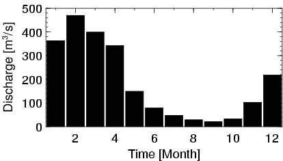
| Station Name (GRDC ID): | Jacinto (3649211) | Basin Name: | Tocantins |
|---|---|---|---|
| River Name: | Rio Santa Tereza | Next Downstream Station: | Conceicao do Araguaia (3649416) |
| GRDC Country Code: | BZ | Distance to Next Downstream Station: | 456 km |
| Start Year [Month]: | 1971 [12] | Upstream Station(s): | None |
| End Year [Month]: | 1991 [3] | ||
| Mean Discharge: | 188 m3/s | ||
| Minimum Discharge: | 4 m3/s | ||
| Maximum Discharge: | 836 m3/s | Length of Upstream Mainstem: | 245 km |
| Mean Interstation Discharge: | 188 m3/s | Distance to Basin Outlet: | 1492 km |
| GRDC Catchment Area: | 13811 km2 | STN Catchment Area: | 12048 km2 |
| GRDC Interstation Area: | 13811 km2 | STN Interstation Area: | 12048 km2 |
| GRDC Station Runoff: | 429 mm/yr | STN Station Runoff: | 491 mm/yr |
| GRDC Interstation Runoff: | 429 mm/yr | STN Interstation Runoff: | 491 mm/yr |
| Station Field Descriptions | Basin Field Descriptions | ||
| Download | |
|---|---|
| Site Descriptor Information | Station Time Series Data |
| Hydrograph | Station Data | ||||||||||||||||||||||||||||||||||||||||||||||||||||||||
|---|---|---|---|---|---|---|---|---|---|---|---|---|---|---|---|---|---|---|---|---|---|---|---|---|---|---|---|---|---|---|---|---|---|---|---|---|---|---|---|---|---|---|---|---|---|---|---|---|---|---|---|---|---|---|---|---|---|
|
| ||||||||||||||||||||||||||||||||||||||||||||||||||||||||
