 |
 |
|
|
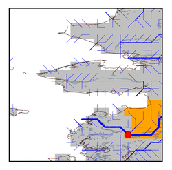
| Station Name (GRDC ID): | Pilot Station (4103200) | Basin Name: | Yukon |
|---|---|---|---|
| River Name: | Yukon | Next Downstream Station: | None |
| GRDC Country Code: | US | Distance to Next Downstream Station: | N.A. |
| Start Year [Month]: | 1975 [10] | Upstream Station(s): | Kaltag, Alas. (4103300) |
| End Year [Month]: | 1993 [9] | ||
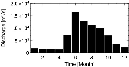
| Mean Discharge: | 6347 m3/s | ||
| Minimum Discharge: | 985 m3/s | ||
| Maximum Discharge: | 23667 m3/s | Length of Upstream Mainstem: | 2552 km |
| Mean Interstation Discharge: | 307 m3/s | Distance to Basin Outlet: | 225 km |
| GRDC Catchment Area: | 831390 km2 | STN Catchment Area: | 840586 km2 |
| GRDC Interstation Area: | 64390 km2 | STN Interstation Area: | 71605 km2 |
| GRDC Station Runoff: | 241 mm/yr | STN Station Runoff: | 238 mm/yr |
| GRDC Interstation Runoff: | 150 mm/yr | STN Interstation Runoff: | 135 mm/yr |
| Station Field Descriptions | Basin Field Descriptions | ||
| Download | |
|---|---|
| Site Descriptor Information | Station Time Series Data |
| Hydrograph | Station Data | ||||||||||||||||||||||||||||||||||||||||||||||||||||||||
|---|---|---|---|---|---|---|---|---|---|---|---|---|---|---|---|---|---|---|---|---|---|---|---|---|---|---|---|---|---|---|---|---|---|---|---|---|---|---|---|---|---|---|---|---|---|---|---|---|---|---|---|---|---|---|---|---|---|
|
| ||||||||||||||||||||||||||||||||||||||||||||||||||||||||
