 |
 |
|
|
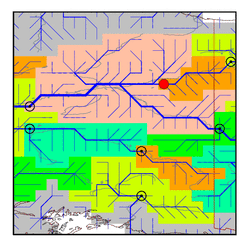
| Station Name (GRDC ID): | Fort Yukon, Alas. (4103700) | Basin Name: | Yukon |
|---|---|---|---|
| River Name: | Porcupine River | Next Downstream Station: | near Stevens Village (4103550) |
| GRDC Country Code: | US | Distance to Next Downstream Station: | 341 km |
| Start Year [Month]: | 1965 [1] | Upstream Station(s): | Old Crow (4203050) |
| End Year [Month]: | 1979 [9] | ||
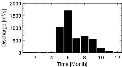
| Mean Discharge: | 410 m3/s | ||
| Minimum Discharge: | 0 m3/s | ||
| Maximum Discharge: | 2790 m3/s | Length of Upstream Mainstem: | 597 km |
| Mean Interstation Discharge: | 91 m3/s | Distance to Basin Outlet: | 1501 km |
| GRDC Catchment Area: | 76405 km2 | STN Catchment Area: | 76724 km2 |
| GRDC Interstation Area: | 21005 km2 | STN Interstation Area: | 21766 km2 |
| GRDC Station Runoff: | 169 mm/yr | STN Station Runoff: | 169 mm/yr |
| GRDC Interstation Runoff: | 137 mm/yr | STN Interstation Runoff: | 132 mm/yr |
| Station Field Descriptions | Basin Field Descriptions | ||
| Download | |
|---|---|
| Site Descriptor Information | Station Time Series Data |
| Hydrograph | Station Data | ||||||||||||||||||||||||||||||||||||||||||||||||||||||||
|---|---|---|---|---|---|---|---|---|---|---|---|---|---|---|---|---|---|---|---|---|---|---|---|---|---|---|---|---|---|---|---|---|---|---|---|---|---|---|---|---|---|---|---|---|---|---|---|---|---|---|---|---|---|---|---|---|---|
|
| ||||||||||||||||||||||||||||||||||||||||||||||||||||||||
