 |
 |
|
|
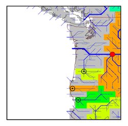
| Station Name (GRDC ID): | The Dalles, Oreg. (4115200) | Basin Name: | Columbia |
|---|---|---|---|
| River Name: | Columbia | Next Downstream Station: | None |
| GRDC Country Code: | US | Distance to Next Downstream Station: | N.A. |
| Start Year [Month]: | 1878 [6] | Upstream Station(s): | Clarkston, Wash. (4116180) Birchbank (4215200) International Boundary (4215220) |
| End Year [Month]: | 1988 [9] | ||
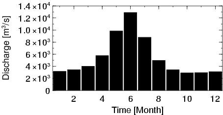
| Mean Discharge: | 5438 m3/s | ||
| Minimum Discharge: | 1201 m3/s | ||
| Maximum Discharge: | 28377 m3/s | Length of Upstream Mainstem: | 1530 km |
| Mean Interstation Discharge: | 1238 m3/s | Distance to Basin Outlet: | 300 km |
| GRDC Catchment Area: | 613830 km2 | STN Catchment Area: | 656568 km2 |
| GRDC Interstation Area: | 193130 km2 | STN Interstation Area: | 232154 km2 |
| GRDC Station Runoff: | 279 mm/yr | STN Station Runoff: | 261 mm/yr |
| GRDC Interstation Runoff: | 202 mm/yr | STN Interstation Runoff: | 168 mm/yr |
| Station Field Descriptions | Basin Field Descriptions | ||
| Download | |
|---|---|
| Site Descriptor Information | Station Time Series Data |
| Hydrograph | Station Data | ||||||||||||||||||||||||||||||||||||||||||||||||||||||||
|---|---|---|---|---|---|---|---|---|---|---|---|---|---|---|---|---|---|---|---|---|---|---|---|---|---|---|---|---|---|---|---|---|---|---|---|---|---|---|---|---|---|---|---|---|---|---|---|---|---|---|---|---|---|---|---|---|---|
|
| ||||||||||||||||||||||||||||||||||||||||||||||||||||||||
