 |
 |
|
|
| Station Name (GRDC ID): | Clarkston, Wash. (4116180) | Basin Name: | Columbia |
|---|---|---|---|
| River Name: | Snake River | Next Downstream Station: | The Dalles, Oreg. (4115200) |
| GRDC Country Code: | US | Distance to Next Downstream Station: | 290 km |
| Start Year [Month]: | 1915 [10] | Upstream Station(s): | None |
| End Year [Month]: | 1972 [12] | ||
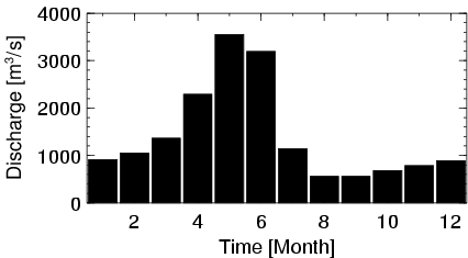
| Mean Discharge: | 1415 m3/s | ||
| Minimum Discharge: | 311 m3/s | ||
| Maximum Discharge: | 5889 m3/s | Length of Upstream Mainstem: | 1253 km |
| Mean Interstation Discharge: | 1415 m3/s | Distance to Basin Outlet: | 589 km |
| GRDC Catchment Area: | 267300 km2 | STN Catchment Area: | 270819 km2 |
| GRDC Interstation Area: | 267300 km2 | STN Interstation Area: | 270819 km2 |
| GRDC Station Runoff: | 167 mm/yr | STN Station Runoff: | 165 mm/yr |
| GRDC Interstation Runoff: | 167 mm/yr | STN Interstation Runoff: | 165 mm/yr |
| Station Field Descriptions | Basin Field Descriptions | ||
| Download | |
|---|---|
| Site Descriptor Information | Station Time Series Data |
| Hydrograph | Station Data | ||||||||||||||||||||||||||||||||||||||||||||||||||||||||
|---|---|---|---|---|---|---|---|---|---|---|---|---|---|---|---|---|---|---|---|---|---|---|---|---|---|---|---|---|---|---|---|---|---|---|---|---|---|---|---|---|---|---|---|---|---|---|---|---|---|---|---|---|---|---|---|---|---|
|
| ||||||||||||||||||||||||||||||||||||||||||||||||||||||||
