 |
 |
|
|
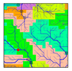
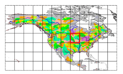
| Station Name (GRDC ID): | Yankton, S.D. (4121800) | Basin Name: | Mississippi |
|---|---|---|---|
| River Name: | Missouri | Next Downstream Station: | Nebraska City, Nebr. (4122650) |
| GRDC Country Code: | US | Distance to Next Downstream Station: | 331 km |
| Start Year [Month]: | 1930 [10] | Upstream Station(s): | Culbertson, Mont. (4120900) Sidney, Mont. (4120950) |
| End Year [Month]: | 1984 [12] | ||
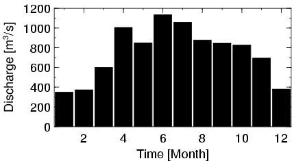
| Mean Discharge: | 749 m3/s | ||
| Minimum Discharge: | 106 m3/s | ||
| Maximum Discharge: | 4757 m3/s | Length of Upstream Mainstem: | 2077 km |
| Mean Interstation Discharge: | 9 m3/s | Distance to Basin Outlet: | 2149 km |
| GRDC Catchment Area: | 723900 km2 | STN Catchment Area: | 716161 km2 |
| GRDC Interstation Area: | 307790 km2 | STN Interstation Area: | 322792 km2 |
| GRDC Station Runoff: | 33 mm/yr | STN Station Runoff: | 33 mm/yr |
| GRDC Interstation Runoff: | 1 mm/yr | STN Interstation Runoff: | 1 mm/yr |
| Station Field Descriptions | Basin Field Descriptions | ||
| Download | |
|---|---|
| Site Descriptor Information | Station Time Series Data |
| Hydrograph | Station Data | ||||||||||||||||||||||||||||||||||||||||||||||||||||||||
|---|---|---|---|---|---|---|---|---|---|---|---|---|---|---|---|---|---|---|---|---|---|---|---|---|---|---|---|---|---|---|---|---|---|---|---|---|---|---|---|---|---|---|---|---|---|---|---|---|---|---|---|---|---|---|---|---|---|
|
| ||||||||||||||||||||||||||||||||||||||||||||||||||||||||
