 |
 |
|
|
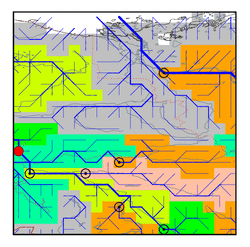
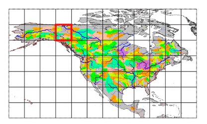
| Station Name (GRDC ID): | Dawson (4203200) | Basin Name: | Yukon |
|---|---|---|---|
| River Name: | Yukon River | Next Downstream Station: | Eagle (4103800) |
| GRDC Country Code: | CN | Distance to Next Downstream Station: | 140 km |
| Start Year [Month]: | 1966 [1] | Upstream Station(s): | Mayo (4203150) above White River (4203250) |
| End Year [Month]: | 1980 [12] | ||
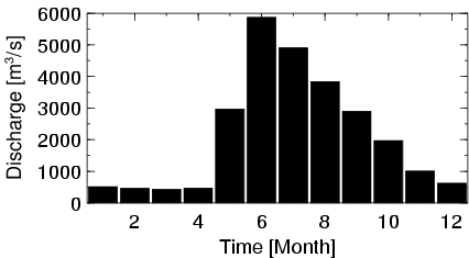
| Mean Discharge: | 2160 m3/s | ||
| Minimum Discharge: | 273 m3/s | ||
| Maximum Discharge: | 8040 m3/s | Length of Upstream Mainstem: | 861 km |
| Mean Interstation Discharge: | 591 m3/s | Distance to Basin Outlet: | 1910 km |
| GRDC Catchment Area: | 264000 km2 | STN Catchment Area: | 264496 km2 |
| GRDC Interstation Area: | 82441 km2 | STN Interstation Area: | 86300 km2 |
| GRDC Station Runoff: | 258 mm/yr | STN Station Runoff: | 258 mm/yr |
| GRDC Interstation Runoff: | 226 mm/yr | STN Interstation Runoff: | 216 mm/yr |
| Station Field Descriptions | Basin Field Descriptions | ||
| Download | |
|---|---|
| Site Descriptor Information | Station Time Series Data |
| Hydrograph | Station Data | ||||||||||||||||||||||||||||||||||||||||||||||||||||||||
|---|---|---|---|---|---|---|---|---|---|---|---|---|---|---|---|---|---|---|---|---|---|---|---|---|---|---|---|---|---|---|---|---|---|---|---|---|---|---|---|---|---|---|---|---|---|---|---|---|---|---|---|---|---|---|---|---|---|
|
| ||||||||||||||||||||||||||||||||||||||||||||||||||||||||
