 |
 |
|
|
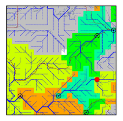
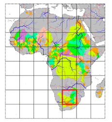
| Station Name (GRDC ID): | Engelbrechtsdrift (1159800) | Basin Name: | Orange |
|---|---|---|---|
| River Name: | Vaal | Next Downstream Station: | de Hoop 65 (1159500) |
| GRDC Country Code: | ZA | Distance to Next Downstream Station: | 420 km |
| Start Year [Month]: | 1964 [10] | Upstream Station(s): | None |
| End Year [Month]: | 1986 [9] | ||
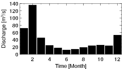
| Mean Discharge: | 39 m3/s | ||
| Minimum Discharge: | 0 m3/s | ||
| Maximum Discharge: | 1110 m3/s | Length of Upstream Mainstem: | 333 km |
| Mean Interstation Discharge: | 39 m3/s | Distance to Basin Outlet: | 1557 km |
| GRDC Catchment Area: | 38564 km2 | STN Catchment Area: | 46741 km2 |
| GRDC Interstation Area: | 38564 km2 | STN Interstation Area: | 46741 km2 |
| GRDC Station Runoff: | 32 mm/yr | STN Station Runoff: | 26 mm/yr |
| GRDC Interstation Runoff: | 32 mm/yr | STN Interstation Runoff: | 26 mm/yr |
| Station Field Descriptions | Basin Field Descriptions | ||
| Download | |
|---|---|
| Site Descriptor Information | Station Time Series Data |
| Hydrograph | Station Data | ||||||||||||||||||||||||||||||||||||||||||||||||||||||||
|---|---|---|---|---|---|---|---|---|---|---|---|---|---|---|---|---|---|---|---|---|---|---|---|---|---|---|---|---|---|---|---|---|---|---|---|---|---|---|---|---|---|---|---|---|---|---|---|---|---|---|---|---|---|---|---|---|---|
|
| ||||||||||||||||||||||||||||||||||||||||||||||||||||||||
